Our summer reading list

Comment

Our summer reading list

Summer is upon us here in D.C. despite the official start of summer still a few days away. To celebrate, here is a short list of water-related books we plan to read this summer. We tried to be mindful of how well each book can travel when you head out on the river or into the mountains this summer. Have a book recommendation for us? Drop us a line in the comments!

Rancher Farmer Fisherman
Travel down the Mississippi River and learn from residents who wouldn't self-describe as environmentalists but feel a moral responsibility to preserve natural wealth and ensure their communities will survive for the next generation.

Drawdown: The most comprehensive plan ever proposed to reverse global warming
The authors take a comprehensive look at climate change solutions from the low-hanging fruit to the innovative and bold. We hope to be inspired and come away with new ideas for adapting to and slowing the pace of climate change.

Natural Capitalism
First published in 1999 this book outlines a framework which blends environmental sustainability and corporate profits around the principle that business is good for the environment.

Comment

Rappahannock: A River at Risk

Rappahannock: A River at Risk

We recently teamed up with Chesapeake Commons to take a deep dive into natural gas and oil development in the Rappahannock River basin in Central Virginia. American Rivers highlighted the issues in their latest list of America's Most Endangered Rivers but we went a few steps further to better understand what part of the watershed is most at risk, what water and natural resources could be impacted and, most importantly, what policies or planning initiatives can protect the longest free-flowing river in the eastern U.S. Head over to Chesapeake Commons to read our analysis and view the interactive maps!

Introducing a new logo design!

We (er, our graphic designer) have been hard at work designing a new logo over the past couple of weeks. We are really excited to reveal the new look and feel of GPA! The redesign reaffirms our commitment to assisting communities with source water protection, watershed management, and solving complex environmental issues through geodesign, geoanalytics, and data-driven decision-making. Plus, we feel the new design brings a fresh, clean, fun look to our work. After all we love what we do and we have a ton of fun doing it! Drop us a line and tell us what you think. And stay tuned for some small upgrades to the website, too!

logo_horizontal
logo_primary

How outdoor recreation can bring an economic boom back to coal country

How outdoor recreation can bring an economic boom back to coal country

The good news for struggling communities across Appalachia is that they don't need to reinvent the wheel. Old mining communities in the Southwest have successfully diversified their regional and local economy centered around outdoor recreation.

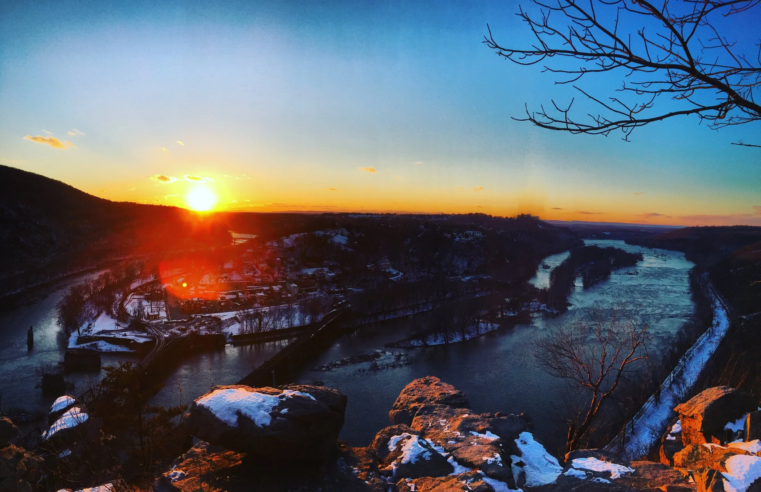
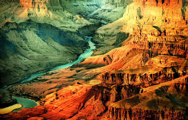
When we think of Moab, UT, gateway to Canyonlands and Arches National Park immediately come to mind. We also think of the world class mountain bike trails along Porcupine Rim and rafting sections of the mighty Colorado River. The area boasts epic 4-wheel driving across the most unique scenery in the American Southwest, too. It is no wonder people refer to Moab as the outdoor adventure capital of the U.S.

But it was not always this way. Moab came of age as a mining town when Vanadium was first discovered in 1912 and, by 1920, the area had produced $2.4 million in uranium. During the early years of the Cold War, demand for uranium skyrocketed and the Town of Moab enjoyed an economic boom until demand for uranium began to subside in the early 1960s. In 1964 the largest mine closed and the mill laid off hundreds of workers. For the next two decades mines continued to close and the unemployment rate hovered around 15 percent. During the same period, the population of Moab decreased by 23 percent. Decades of mining activities also left behind an environmental legacy of superfund sites and contaminated soils along the banks of the Colorado River.

Community leaders began viewing tourism as an economic safety net in the 1970s but it took another ten years before tourism was embraced as the future of Moab. Community development officials invested heavily to support a tourism-based economy and today mining and oil and gas account for three percent of the local labor force. Government agencies charged with land management and the service industry are the regions primary employers. The service industry supports more than 1 million visitors annually.

There are many parallels between Moab, UT, and communities across Appalachia coal country. For generations, coal mining and related industries employed and supported entire communities. But like all mining industries, there were boom and bust cycles and today coal employs 70,000 (compared to 260,000 in the solar industry). Communities are now grappling with high unemployment and shrinking populations. Fortunately, many of these communities are adjacent to public lands or abandoned mine sites with outdoor recreation potential. With a bold vision and proper investments, these communities can embrace conservation and outdoor recreation as a catalyst for economic development similar to Moab in the 1980s. Coal Township, Pennsylvania, has already embraced the outdoor recreation economy by supporting the remediation and conversion of a 6,500 acre mine site into hundreds of miles of trails for hiking, mountain biking, and all-terrain vehicles. The Anthracite Outdoor Adventure Area opened in 2013 and hosts 10,000 visitors annually.

Nationally, $1 out of every $20 in consumer spending goes towards outdoor recreation. A new report published by the Outdoor Industry Association (OIA) estimates the outdoor recreation economy generates $887 billion in consumer spending annually and employs 7.6 million Americans returning $59.2 billion to state and local coffers. The OIA report calculates $10 billion was returned to state and local coffers across Appalachia.

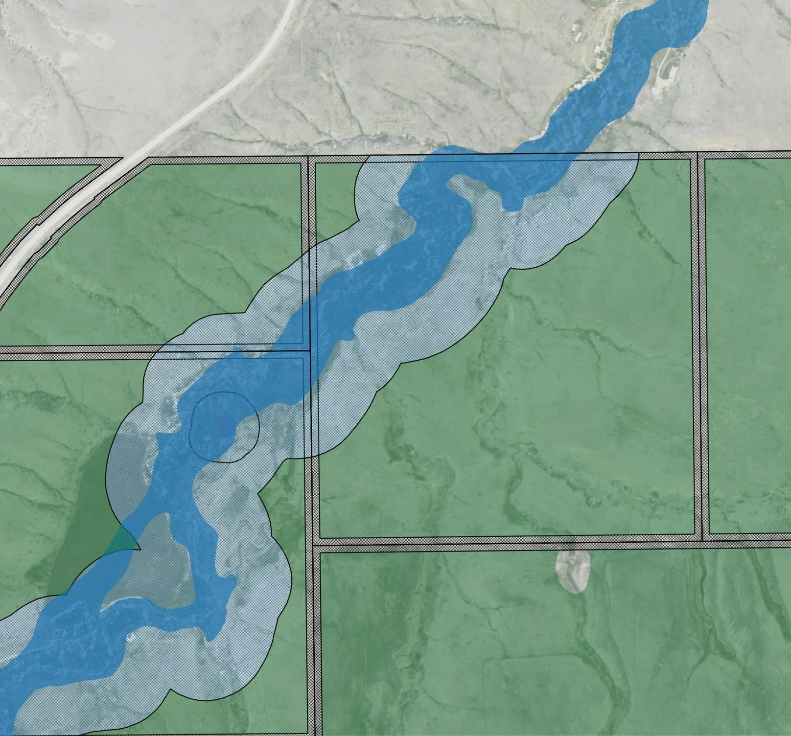
To take full advantage of the outdoor recreation economy, environmental restoration and remediation is an important first step for Appalachian communities. A healthy outdoor recreation industry is dependent on healthy lands and waters. Decades of mining activities across Appalachia left thousands of miles of streams filled in with mine waste, contaminated soil and water supplies with heavy metals, and reshaped the landscape through surface mining. Many communities that stand to benefit from investments in the outdoor recreation economy are also suffering from contaminated drinking water supplies. Environmental remediation will require major investment and can help support communities in the interim. Environmental remediation is a $15 billion industry employing 86,000 across the country. These are good-paying and long-term jobs. Superfund site remediation takes several years to decades to completely remove industrial and chemical contaminants from soils or groundwater. The Moab UMTRA Project began removing and disposing of contaminated soil along the banks of the Colorado River in 2009 and the project is expected to continue until 2032.

Investments in environmental cleanup projects bring multiple benefits including near and long-term economic opportunity, improved water quality and drinking water supplies, and healthy ecosystems to support a thriving outdoor recreation and tourism economy. Fortunately, Appalachia can look to communities in the Southwest for a road map to bring economic and environmental prosperity back to the region.

Solar panel siting using custom QGIS plugins

Solar panel siting using custom QGIS plugins

GPA is wrapping up an exciting month-long project to build Hexagon Energy a custom QGIS plugin to assist project managers in identifying appropriate locations for solar panel placement at the parcel level. When incorporated into their existing development workflows, this plugin will identify the area within individual parcels for solar panel placement taking into consideration setbacks from property lines, floodplains, and wetlands. Project managers can take this information into the field, sit across the table from landowners and be more prepared to discuss contract details; reducing the development timeline and installing solar panels more efficiently and quickly.

The custom plugin is built on QGIS open source python scripting libraries and can be downloaded directly into a QGIS project. After project staff have run through the initial site selection process at a county (or regional) level to identify priority parcels for further investigation, marketing and outreach, staff load the primary datasets for analysis. The plugin allows users to define setback requirements based on specific county development codes or ordinances making the plugin functional across all geographic regions.

plugin.JPG

The plugin returns a vector shapefile of buildable area by parcel. The buildable area vector file retains the original parcel information allowing for easy owner look-up and calculating total acreage of buildable area. This tool replaces the need for project managers to manually outline and estimate buildable area using Google Earth or other web service data layers. Future versions of the plugin will incorporate slope and aspect to further refine the total buildable area.

Source water protection is job protection, too

Business and industry rely on clean, safe, and reliable water as much as we rely on it to drink. A new report by the Value of Water Campaign estimates the average US business loses $230 in sales per employee for every day of water service disruption. Nationally, a one-day disruption in water service amounts to $43.5 billion in lost sales and $22.5 billion in GDP putting 250,000 jobs at risk. There is also a direct relationship between water quality and treatment costs. Business and industry requires high quality water as raw inputs in manufacturing, agriculture, pharmaceuticals to name a few. If water quality doesn’t meet industry standards, businesses have to invest more capital into treating water on-site (or relocate to areas with better water quality) thus increasing the cost to do business and risking additional jobs.

Source water protection is a worthy (and smart) investment. Protecting water quality at the source on public lands, in forests, and in rural areas of the country means less infrastructure and treatment is required to deliver high quality water to businesses, industry, and residents. New York City saves an estimated $300 million a year on water treatment and maintenance costs through their source water protection program. The Nature Conservancy estimates the cost of source water protection activities is $2 per person per year. Investing in forest conservation, sustainable agriculture, protecting public lands, and maintaining and improving riparian buffers improves water quality and benefits everyone. Furthermore, investments in source protection enhances our resiliency in an unpredictable climate where water scarcity concerns are growing around the globe.

Investing in source water protection programs is an investment in local economies while reducing the financial burden on businesses, industry, and residents. That’s a worthy investment to make.

And...We're off!

Colleagues, friends, and family:

As many of you know, I’ve been providing geospatial analysis and environmental planning consulting services part time through my company, Geospatial Planning Advisors (GPA), over the past few years. Last February I accepted a one year position as a Water Resources Fellow with the Interstate Commission on the Potomac River Basin even as I continued to work on small consulting projects on the side. It was at times a hectic year but nonetheless a rewarding experience.

I am excited to announce that I am transitioning to GPA full time beginning today and have a number of contracts lined up.  We are also seeking funding to develop a web app to assess watershed restoration projects at a watershed scale. GPA is an environmental and land use planning firm focused on the intersection of policy and technology, utilizing GIS to help solve complex environmental problems. We have experience in watershed management, conservation planning, sustainable economic development, spatial planning, and renewable energy development.

I recently asked my good friend and colleague from Cal Poly, Kyle Perata, to join me in this endeavor. We look forward to working with you to make positive change in the environment and in our communities in 2017 and beyond.

Please check out our website www.geospatialplanning.org or follow us on Facebook. Give us a shout if you have any advice, leads, or just want to talk about maps sometime.

Congress continues to push false choice between jobs and clean drinking water

Republicans in Congress recently used the Congressional Review Act to kill an Obama-era regulation known as the Coal Stream Protection Rule. The rule prohibited coal mining companies from dumping waste into adjacent streams and required companies to prepare a plan for restoring damaged streams after mining is complete. In many cases, the physical damage to adjacent streams and toxic chemical by-products entering the water are the same streams suppling local communities with drinking water. The very same people often employed by these mining companies are, at the same time, drinking water poisoned by mining activities.

By repealing the Coal Stream Protection Rule, Republicans continue to present a false choice. Either you can have a (coal) job or clean, safe, and reliable drinking water. Proponents of coal mining (or other extractive industries) will argue environmental regulations create undue burden on mining operations and, therefore, result in fewer industry jobs. However, the coal industry in particular has suffered recently because the price of natural gas had made coal mining less attractive economically and not because of environmental regulations. Moreover, the argument says you can either have a job or clean drinking water but you can't possibly have both.

There is no doubt communities in Appalachia are struggling. Persistently high unemployment rates in communities where coal was the only game in town is a real issue for policymakers and planners alike. If congressional Republicans were serious about helping these communities they would seek policies to diversifying local economies, provide workforce training programs, and provide job placement services to help communities adapt to a changing economy. Instead, Republicans continue to pander towards corporate interests seeking to extract the last bit of profit from a dying industry at the expense of the constituents who sent them to Washington in the first place.

Let us consider an alternative solution that could provide hard hit communities with well paying jobs while also providing an environmental benefit. According to the Sierra Club, mountain top removal mining has damaged or destroyed 2,000 miles of streams. Many of these streams supply drinking water to nearby communities. What if Congress passed a spending bill or other legislation to encourage environmental remediation in areas impacted by mining operations? A 2011 report from the Brookings Institute estimates environmental remediation employs almost 60,000 nationwide. More recent market analysis estimates the industry employs 86,000. All told, the industry is valued between $13 billion and $15 billion. Federal investment in these communities to retrain unemployed coal workers for environmental remediation jobs and then putting them to work repairing damaged streams and improving water quality will bring well paying jobs and healthier communities hard hit by economic decline and disinvestment across coal country. Additionally, communities would save money on drinking water treatment thus allowing cash-strapped cities to spend money on other community services. Investing in environmental remediation would employ people in good paying jobs, improve drinking water quality and aquatic ecosystems, and improve public health.

These are the kinds of investments we should be making in our communities rather than doubling down on the failed policies of the past. Nobody should have to decide between a job and clean drinking water. It is possible to have both.

Are solar panels the new cover crop in Virginia?

Are solar panels the new cover crop in Virginia?

A new law introduced in the 2017 General Assembly will allow agriculture net metering for solar arrays and allow farmers to sell excess energy back to utilities at market rates. Existing state legislation does not allow owners of small, detached solar arrays to sell energy back to utilities.

This is great news for advocates of renewable energy but also great news for water resource professionals. If passed, this is another tool in the toolbox planners can use to reduce nutrient pollution from agriculture and improve local water quality. Under this bill, farmers have another option for supplementing income on low-yield fields. Instead of asking farmers to carry the financial burden of removing land from production, small solar arrays can help offset the costs of leaving land fallow beyond the lifetime of agriculture cost-share programs. Moreover, solar development will provide a more consistent revenue stream for landowners. As the weather becomes less predicable in a changing climate, solar power development can be an insurance policy against a less certain future growing season.

Of course small-scale solar arrays will not be the solution for all farmers; however, through geospatial analysis, low-yield fields with high potential for solar power development can be targeted as a component of watershed management plans where nutrient runoff is causing water quality impairments. Removing low-yield, high-nutrient runoff land from agriculture production and installing solar panels is a win-win-win for farmers, watershed managers, and renewable energy advocates.

Alternatives to the Grand Canyon Escalade Project

Alternatives to the Grand Canyon Escalade Project

As we head into the final weeks of 2016, the environmental and conservation community has a lot to be thankful for this past year. While 2016 was in many respects a year we'd all love to put behind us, conservationists can pause to celebrate a few victories on public lands, from new monument designations to a formal recommendation to the Navajo Council to reject the Grand Canyon Escalade Project.

The fight to block the Grand Escalade Project is a sad reminder that we will forever have to be vigilant to prevent inappropriate development benefiting a few at the expense of all on our public lands. The grassroots effort to reject the project was, without a doubt, a major victory.

While the environmental and conservation communities have reason to celebrate a victory at the Grand Canyon, we must not turn our backs on the underlying and systemic reasons project like these continue to put pressure our public lands. There are communities which suffer systemically from high levels of poverty, low educations rates, lack of economic opportunities, high drug use, etc. These communities are desperate for anything that will bring the promise of economic prosperity--even at the risk of destroying a culturally sacred monument--in the hopes of a better and more secure economic future. Until we solve these underlying issues, we will continue to see short-sighted project proposals such as the Grand Escalade Project.

My challenge to the conservationists and environmentalists: let's offer real solutions as alternatives to these types of destructive projects in 2017. Let us not simply mobilize to block a bad project proposal but instead offer a better solution. The Grand Escalade Project is not the sustainable approach to development but there are sustainable alternatives. Instead of reject the Grand Escalade Project, let's direct investment in renewable energy infrastructure or support the growth of the sustainable tourism industry in underserved communities through micro loans and small business development. Let's invest in expanding the reach of broadband internet and ensuring a safe and reliable source of drinking water. Let us not simply show up to oppose development but let us lead the way in sustainable alternatives. 

We must work proactively with these communities to solve the systemic economic and social shortcomings. Then, just maybe,  our grandchildren will not have to fight these same battles to protect our public lands.

Photo Credit: Aftab Uzzaman (Creative Commons)

Photo Credit: Aftab Uzzaman (Creative Commons)

Webmap: Community Gardens of DC

Webmap: Community Gardens of DC

Originally created as a Mystery Map for Greater Greater Washington, we converted this static map of community gardens in Washington, D.C., into an interactive web directory. Click on each community garden to view basic information (name, address, number of plots) with a link to each garden's website to find more information on how to sign-up for a plot.

Are there community gardens missing from the map? Email us with the name, address, and number of plots, and we'll update the directory!

International development organizations face lack of urban planning capacity too

A recent article posted to CitiScope correctly identifies a lack in urban planning capacity at all levels of government in developing countries. As an urban and environmental planner who worked in sub-Saharan Africa, the gap in professionally trained land use and resource managers is staggering. The authors of the article correctly point out the lack of planning education in institutions, combined with the old ways of thinking in the few programs which do exist, are inhibiting the ability for policymakers at all levels of government to grasp the complexity of rapid urbanization and natural resource development. Combined with the traditional silo approach to international development, a perfect storm for failing economic development policies and programs will continue to perpetuate the same old problems of persistent poverty, food insecurity, poor infrastructure, etc.

As the United Nations works to finalize the new urban development agenda, I would like to point out the gap in urban planning knowledge within the very institutions seeking to help these economies and communities develop. Too many aide programs are developed with a predetermined answer by bureaucrats and professional grant writers without recognizing the need for fundamental planning and land use studies at the beginning of the project. For example, almost all aide programs are designed around a perceived community need (e.g. lack of infrastructure). An organization will fund a program (either directly or indirectly) to build schools, clinics, roads and other critical infrastructure in these communities. This is achieved without ever thinking about the long-term spatial implications of these policy and infrastructure decisions, or what I call operating in a spatial vacuum.

I encountered a great example of this while working on a spatial development project in Mozambique where local forestry officials were concerned about the recent spike in deforestation rates in a local forest reserve. Through some rudimentary spatial analysis (overlaying a few different data layers), we discovered another government ministry had been building schools for the few communities residing inside the reserve. Logically, the policymakers responsible for providing education facilities for their constituents saw communities lacking in access to education and, thus, built a few schools for these communities. Unbeknownst to them, this new education infrastructure acted as an economic attractor, suddenly bringing in new residents who wanted a piece of the education pie. This increase in development in the forest reserve communities soon began exerting pressure on forest resources leading to increased rates of deforestation.

Our recommendation to community leaders at the time was to be more strategic with infrastructure development decisions. Through spatial analysis, we identified areas outside the forest reserve to build additional infrastructure to help stabilize the local population outside the reserve and keep people from migrating into the reserve. In combination with improved investments in agriculture and forestry development, we proposed a regional economic development strategy to protect the forest reserve while providing critical infrastructure for economic development.

Another example of a lack of urban planning knowledge within aide organizations can be seen in many agriculture development programs. Grants are written to address food insecurity but fail to understand the biophysical constraints necessary for a successful program. A recent agriculture development program at USAID identified hundreds of millions of dollars to fund agriculture development programs in multiple provinces across central Mozambique. The problem however, is the funding was specifically earmarked for several provinces where water resources are already scarce (it is a desert). Not only was the program already set to fail, or at the very least be very costly to implement and sustain economically and environmentally, but we were aware of other locations which were highly suitable for agriculture development (good soils and climate) in neighboring provinces and districts. We recommend to whomever would listen that a land use and resource management plan be part of this agriculture development project to identify suitable areas for implementing agriculture programs. At every turn wee were met with a basic lack of land use planning knowledge.

In short, I'm encouraged by the recent article in CitiScope identifying a great need in the developing parts of the world. The road to self sufficiency starts with the ability to consider long-term resource implications and there is no better profession to handle this enormous task. At the same time, the planning profession needs to insert itself within these aide organizations to ensure the money spent will have lasting impact beyond a single donor cycle.